Land Use
Figure CC-1 illustrates the planned distribution of land uses throughout Burlingame and the sphere of influence. During the extensive community engagement process of 2015-2017, the community identified areas of change and areas of stability. The land use plan focuses growth in the areas of change and preserves the existing fabric in areas of stability. The following land use designation descriptions correspond to Figure CC-1 and define allowable uses and permitted density and intensity ranges.
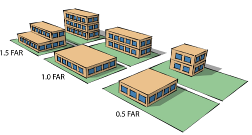
The extent to which properties may be developed or redeveloped over time are expressed in this General Plan in terms of density for residential uses and intensity for nonresidential development. Density reflects how many units may be built per acre of land (units per acre) but does not control building height, setbacks, required open space area, or other development parameters; the details as to how density is implemented are contained in the Zoning Code (Title 25 of the Municipal Code), guided by the vision statements contained in this element. Intensity is expressed using the floor-area ratio (FAR) metric, which measures the total allowable building square footage on a property relative to the size of that property. FAR does not dictate building height or other development standards; again, those regulations are set forth in the Zoning Code. The FAR allows for flexibility in design approaches, as the graphic here illustrates.