An efficient, accessible, and safe multimodal transportation network moves people and goods through the community. In addition to their utilitarian function of moving vehicles, streets can also provide spaces for people to exercise, gather, and conduct business. Burlingame’s streets serve many functions, including:
Allowing people to move about town
Providing access to businesses, homes, schools, parks, and public spaces
Supporting adjacent land uses and developments
Providing safe, attractive areas that encourage personal interactions
Promoting human and environmental health by making it easier and safer to travel by transit, by bicycle, or on foot
Public rights-of-way (roadways, sidewalks, trails, and paths) cover a significant part of any community, generally occupying 20 to 30 percent of a community’s total land area. The layout and use of these areas influence many aspects of the physical environment, including how people move, how people and goods get to homes and businesses, and how frequently people walk, bike, and exercise outdoors. Street and pathway designs also affect the safety and independence of people in the community, especially vulnerable populations such as children, persons with disabilities, and the elderly. A well-planned and well-designed mobility network is a means to realize the community’s goals for improved health, economic growth, quality of life, and fiscal soundness.
With these goals in mind, Burlingame aims to develop a complete multimodal transportation network (Complete Streets network). This network will be designed to encourage people to use non-automobile modes for as many trips as possible, as high use of these alternative modes enables the system to move more people with less delay, cost, and environmental impacts. However, tradeoffs need to be made within each mode to allow safe access for all other modes. Streets are where walking, bicycling, transit, private vehicles, and freight come together to provide mobility to their respective users.
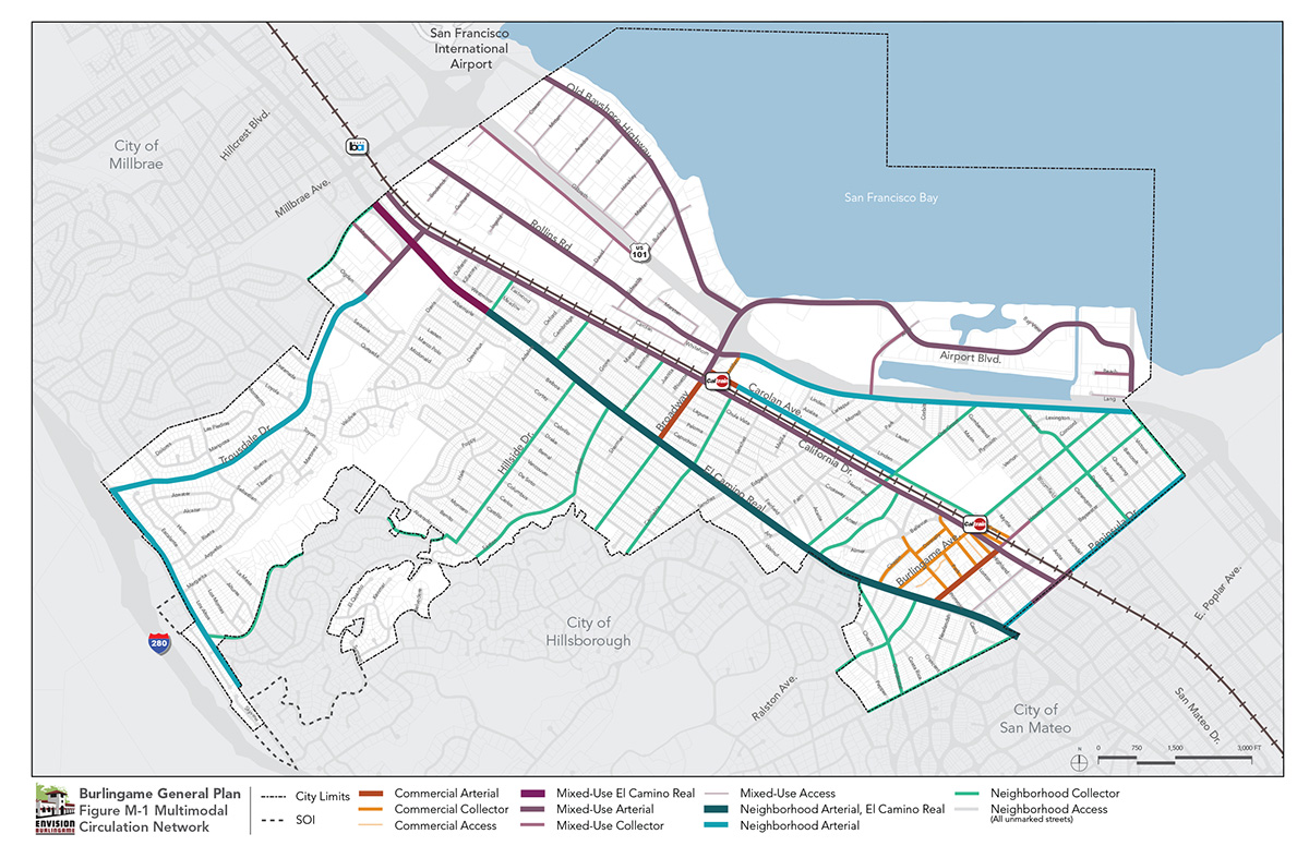
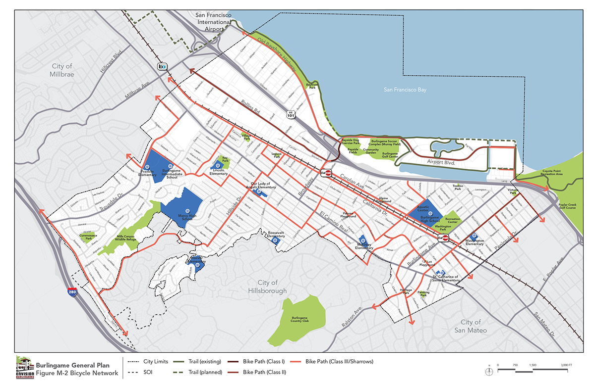
Streets and sidewalks are public spaces that serve many functions: mobility corridors, connections to businesses, places for interaction among neighbors, and even facilities for managing stormwater control. Above all, the primary function is mobility, and different street types accommodate different means of moving about. The City of Burlingame’s street classification system is shown in Figure M-1. It provides a framework for street design and mobility that supports all of these functions and meets the City’s needs for 21st century transportation options.
The street classification system establishes and promotes the suitability of streets to accommodate various travel modes and land uses. In particular, this system is sensitive to local context, land use, built form, and mobility priorities. Each of the classifications aligns with Federal Highway Administration (FHWA) categories, as shown in Table M-1. However, they encompass a more dynamic range of uses than those identified by FHWA. A detailed description of Burlingame’s street classifications and their corresponding FHWA category are shown in Table M-2.
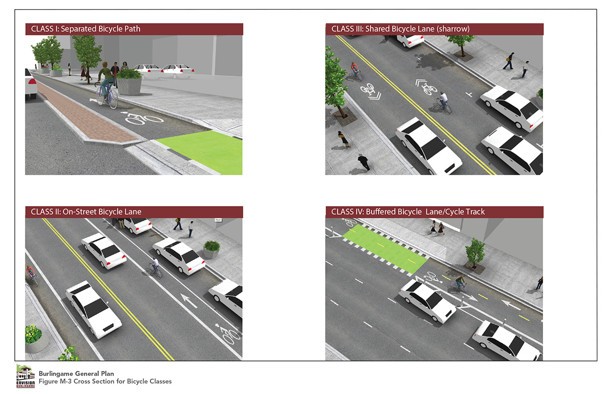
Street uses are independent of their normal form and function, such as routes for emergency vehicles, streets adjacent to major transit stations or school zones, and bicycle priority streets. These uses do not necessarily dictate the specific design of a street but instead encourage design flexibility to better serve the specific purposes. For example, the local access streets that can best serve bicycles should be clearly identified so their roadway and intersection design emphasizes bicycle priority and comfortable access. Similarly, emergency routes may require width and design exceptions to accommodate movements of emergency vehicles; for example, where a roundabout is appropriate for a particular intersection, its edges may need to be rounded so that large fire trucks can roll over rather than have to swerve around them.
Table M-1Relationship between Street Types and FHWA Classifications
Classification
Arterial
Collector
Local
El Camino Real
X
Major Connector
X
X
Minor Connector
X
Access
X
Table M-2Description of Street Classifications
Classification
Description
Example
FHWA Category
Commercial Arterial
Street with commercial frontages with capacity to serve as a main route for multiple modes Distributes trips to commercial areas and provides a balanced level of service for vehicles, transit, bicycles, and pedestrians, wherever possible. Pedestrian improvements are comfortable to walk along and provide safe crossings at designated locations.
Howard Ave (west of California Drive)
Arterial
Major Connector
Street with commercial frontages with capacity to serve as a minor route for multiple modes
Prioritizes walking and bicycling and accommodates intra-city trips while also distributing local traffic to other streets and areas.
X
Commercial Collector
Street with commercial frontages with capacity to serve as a minor route for multiple modes
Prioritizes walking and bicycling and accommodates intra-city trips while also distributing local traffic to other streets and areas.
Burlingame Avenue
Collector
Commercial Access
Low-volume commercial street serving local traffic
Provides access primarily to adjacent streets and nearby uses. These streets should offer safe and inviting places to walk and bike.
Highland Avenue
Local
Mixed Use Arterial, El Camino Real
El Camino Real, regional access corridor with mixed residential and commercial frontages and capacity to serve as a main route for multiple modes
Provides local and regional access, distributes trips to residential and commercial areas, and provides a balanced level of service for vehicles, transit, and pedestrians, where possible. Pedestrian improvements are comfortable to walk along and provide safe crossings at designated locations. Accommodating vehicle traffic while ensuring a high-quality experience for visitors and residents is a key design challenge.
El Camino Real (north of Rosedale Avenue)
Arterial
Mixed Use Arterial
Street with mixed use frontages with capacity to serve as a main route for multiple modes
Distributes trips for mixed use and connecting residential areas, and provides a balanced level of service for vehicles, transit, bicycles, and pedestrians, wherever possible. Pedestrian improvements are comfortable to walk along and provide safe crossings at designated locations.
Rollins Road
Arterial
Mixed Use Collector
Street with mixed use frontages with capacity to serve as a minor route for multiple modes
Prioritizes walking and bicycling and accommodates intra-city trips while also distributing local traffic to other streets and areas.
Adrian Boulevard
Collector
Mixed Use Access
Low-volume mixed use through street serving local traffic
Provides access primarily to adjacent streets and nearby uses. These streets should offer safe and inviting places to walk bike.
Malcolm Road
Local
Neighborhood Arterial,
El Camino Real
El Camino Real, regional access corridor with residential frontages and capacity to serve as a main route for multiple modes
Provides local and regional access, distributes trips to residential and commercial areas, and provides a balanced level of service for vehicles, transit, and pedestrians, where possible. Pedestrian improvements are comfortable to walk along and provide safe crossings at designated locations. Accommodating vehicle traffic while ensuring a high quality of life for residents is a key design challenge.
El Camino Real (south of Rosedale Avenue)
Arterial
Neighborhood Arterial
Primarily residential streets with capacity to serve as a main route for multiple modes
Distributes trips for residential areas and provides a balanced level of service for vehicles, transit, bicycles, and pedestrians, wherever possible. Pedestrian improvements are comfortable to walk along and provide safe crossings at designated locations.
Trousdale Drive (West of Ogden Drive)
Arterial
Neighborhood Collector
Primarily residential streets with capacity to serve as a minor route for multiple modes
Prioritizes walking and bicycling and accommodates intra-city trips while also distributing local traffic to other streets and areas. Accommodating vehicle traffic while ensuring a high quality of life for residents is a key design challenge.
Hillside Drive
Collector
Neighborhood Access
Low-volume residential street serving mostly local traffic
Provides access primarily to adjacent streets and nearby uses. These streets should offer safe and inviting places to walk and bike.
Paloma Avenue
Local
The following goal and policies provide a framework for ensuring that network changes and improvements over time are accomplished in such a way that reduces conflicts and congestion and promotes community health and sustainability.
Goal:
M-1
Achieve and maintain a citywide circulation network that provides safe, efficient, and convenient mobility for all users and modes of transportation
Define and develop a well-connected network of Complete Streets that can move all modes safely, efficiently, and comfortably to promote efficient circulation while also improving public health, safety, and accessibility.
Connect commercial districts, centers of employment, civic uses, parks, schools, and other destinations with high-quality options for all travel modes. Ensure the system accommodates the needs of all users, including youth, the elderly, and people with disabilities.
Ensure that pedestrian and bicyclist safety at intersections is prioritized in roadway improvement projects.
Program Types
The City implements the General Plan goals and policies via programs. After closing this popup window, tap or click one of the program icons to go to a list of the programs that implement this and other related policies.