Corridors and Area Plans
In addition to the citywide goals and policies, initiatives specific to Burlingame’s corridors and districts will allow mobility challenges and objectives to be addressed.
California Drive, a local north-south corridor through Burlingame, has a distinct character, with uses that transition from single-family residential at the north end to neighborhood-serving commercial in the middle to auto dealerships at the south end. Running parallel to El Camino Real and the Caltrain right-of-way, California Drive provides local connections between Millbrae and San Mateo, supports a local SamTrans bus route, and is a designated bike route. This corridor is also a significant connection between the Broadway and Downtown commercial districts.
California Drive has long been a vehicle-dominated street, with narrow sidewalks, infrequent pedestrian crossings, and bicycle facilities consisting of “sharrows” to alert motorists that bicycles may share the outside travel lane. With low vehicle volumes relative to the roadway’s capacity (based on standard traffic engineering practices), this corridor will benefit from an updated design that reallocates excess right-of-way for enhanced pedestrian, bicycle, and transit use. The following goals and policies identify how California Drive will be improved and will enhance connections to local commercial districts and transit hubs.
Goal: M-10
California Drive will be redesigned to support multimodal access, with facilities that encourage active transportation and improved linkages to commercial and residential areas.
Implement a redesign of California Drive consisting of a “road diet” south of Broadway and installation of continuous bicycle facilities to establish a north-south bicycle corridor through Burlingame, connecting to bike facilities in Millbrae and San Mateo. Concepts for sections north of Broadway and between Broadway and Burlingame Avenue focus on traffic calming, providing a continuous bicycle facility, and improving pedestrian connections. These may include:
- North of Broadway: Narrow vehicle lanes in each direction, install a buffered two-way off-street bike path on the east side, narrow parking lanes, and develop a new right-of-way of 42 feet from the west curb to east edge of cycle track, with additional four-and-one-half feet of width from the Southern Pacific easement.
- South of Broadway: Create one through vehicle lane in each direction and one center-running left-turn pocket, install a buffered two-way bike route on the east side with a wide buffer (which could be planted or separated by a curb or other vertical barrier), allow parking on the west side only adjacent to the active space, provide a buffer between pedestrians on the sidewalk and moving vehicles in the street, and maintain the 63 feet of right-of-way from the west curb to the east edge of the cycle track. This configuration will keep bicyclists separated from motor vehicles and will connect seamlessly to a planned two-way bicycle path north of Broadway, providing an inviting continuous north-south bike route for all skill levels.
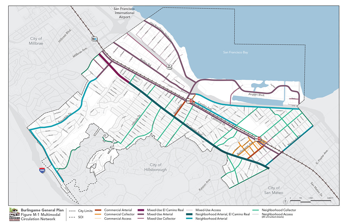
El Camino Real, Spanish for the Royal Road, is a historic travel corridor, having served as the route connecting the 21 Spanish missions in California. Today, El Camino Real continues its function as a critical regional north-south corridor along the Peninsula, connecting cities and providing an alternative commute route to Highway 101 and Interstate 280 (although usually for shorter commute trips). Through Burlingame, El Camino Real has a character clearly distinct from that in cities to the north and south. The eucalyptus trees planted in the early twentieth century survive today, providing a distinctive canopy; collectively, the trees are listed on the National Register of Historic Places as the “Howard-Ralston Eucalyptus Tree Rows.” Land uses in Burlingame largely consist of multifamily housing set back from the street, whereas El Camino Real frontage properties in most other cities have been developed with commercial uses oriented toward motorists.
El Camino Real is owned and managed by the California Department of Transportation (Caltrans) and is designated State Route 82. As of 2017, El Camino Real maintained its original design as regional connector, with two lanes in each direction, narrow and sometimes discontinuous sidewalks, no dedicated right-of-way to accommodate bus loading/unloading, no turning or passing lanes, and long distances between marked pedestrian crossing facilities. El Camino Real presents an east-west barrier for pedestrian connections to residential neighborhoods on both sides of the corridor, and to commercial and employment destinations on the east side. Consistent with its function as a regional route, the roadway supports multiple SamTrans bus routes.
The City has considered options for improving El Camino Real to provide safer crossings for pedestrians and bicycles. The objective is to work with Caltrans to improve safety while retaining the character of the roadway. Refer to the Community Character Element for additional discussion of land use and urban design goals for El Camino Real.
Goal: M-11
Ensure that El Camino Real retains its distinct character as a residential street lined with a historic tree grove, with its function as a regional commute corridor secondary to Burlingame’s vision of the corridor as a lower-speed tree-lined thoroughfare.
Identify high priority locations to improve access, east-west connections, and pedestrian safety along El Camino Real. Coordinate with Caltrans and regional Grand Boulevard Initiative partners (including SamTrans) to update intersection treatments and lane configurations to improve safety while retaining the distinctive character of the roadway.
Broadway traverses east-west across the center of Burlingame, connecting residential neighborhoods west of El Camino Real to California Drive, then extending across the commuter rail line and east to Highway 101. The Broadway/Highway 101 interchange is the only full interchange directly serving Burlingame.
The at-grade crossing at the rail tracks, combined with short distances between intersections along Broadway to Highway 101, has long challenged roadway operations. Also, Broadway serves a dual purpose between California Drive and El Camino Real: as the frontage street for this local commercial district and the key connection to neighborhoods west of El Camino Real. The City looks to Broadway to retain its many functions and to do them all well. Creating a grade separation at the rail line will allow intersection operations to improve and vehicles to move more easily to California Drive. This in turn will provide opportunities to enhance the Broadway commercial district as a local-serving, pedestrian-oriented place, with on-street parking and easily accessible public parking facilities.
Goal: M-12
Allow Broadway to function for dual purposes: as a slow-speed roadway through the Broadway commercial district and as a connector to Highway 101.
Goal: M-13
Ensure that Rollins Road meets the needs of all uses and users within the Rollins Road district.
Ensure that the design of Rollins Road accommodates the mobility and access needs of businesses in the Industrial/Innovation land use district in a manner that responds to the emerging presence of residential uses. Over time, enhance the northern portion of Rollins Road in the Live/Work land use district to support pedestrian activity, balanced with continuing to accommodate truck traffic accessing the Innovation/Industrial land use district to the south.
The Bayfront area will experience increased investment and more intense uses on underutilized properties. The vision of creating a much more vibrant hospitality and business district requires that multimodal infrastructure improvements be provided to better connect uses and provide travel options for visitors. Old Bayshore Highway and Airport Boulevard will both be improved to accommodate users looking to access the recreation amenities along the Bayfront and to visit the mix of uses in the area. In addition to their new multimodal functions, the streets will have attractive urban design treatments that create a distinct identity for the Bayfront. Furthermore, the City will investigate options for crossing Highway 101, such as establishing an additional bicycle/pedestrian crossing as described in the overarching policies for this element.
Goal: M-14
Reinvent Old Bayshore Highway and Airport Boulevard as multimodal streets, and enhance connections between the Bayfront and the balance of the city.
Neighborhood streets throughout Burlingame are the primary trip origins for residents and provide the essential connections to local destinations such as schools. The following goal and policies identify ways to improve the functionality of neighborhood streets.
Goal: M-15
Ensure that neighborhood streets are safe and provide efficient vehicular access to residential neighborhoods and schools.