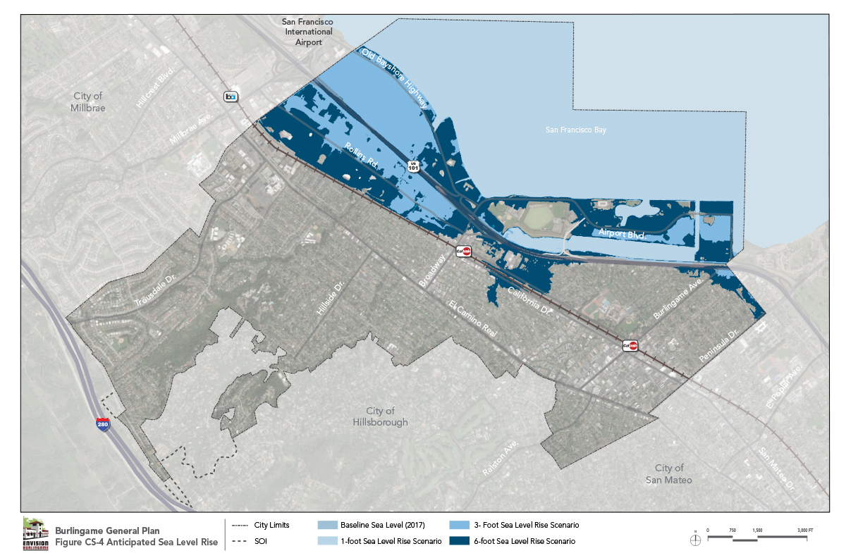
Water levels in San Francisco Bay have risen over eight inches since the early twentieth century and, because of the effects of climate change, are predicted to continue rising at a faster rate. Based on the best available data and a baseline year of 2016, the City can anticipate 10 to 17 inches of sea level rise by the year 2050, and 17 to 32 inches by 2070. The City will become increasingly vulnerable to water inundation during both normal high tides and major storm events. Rising sea levels may inundate the land along the Bayfront and flood nearby industrial, commercial, and residential areas. Figure CS-4 indicates projected ranges of sea level rise and the areas that would be impacted.
Ultimately, sea level rise will have an impact on the community. The City of Burlingame is committed to being proactive at addressing sea level rise and will establish specific building and habitable space setback requirements, shoreline protection measures (in coordination with regional strategies), and use requirements such as limiting certain activities on ground floors.
Unlike some other Peninsula and Bay Area communities, the Burlingame shoreline is not protected by natural defenses such as beaches or wetlands. Ordinarily such defenses create a natural buffer between the Bay and built environment, and can provide protection from wave action and flooding.
Given current and future land uses along the shoreline, a strategy involving “retreat” may not be practical. However, while most of Burlingame’s Bayfront has a hard edge lacking buffer from rising water levels, new development is required to be set back at least 75 feet from the shoreline. This shoreline setback area presents an opportunity to create a buffer and accommodate defenses in the future to mitigate the impacts of sea level rise, as well as provide a recreation amenity through a continuous Bay Trail. As noted in the Community Character Element, preserving options for addressing sea level rise will allow the City to respond to conditions in a manner that is comprehensive and reactive to actual impacts over time.
The following goal and policies reflect the City’s approach to protecting existing and future urban uses along the Bayfront and other vulnerable parts of Burlingame from the impacts of rising sea levels.