Planning Context
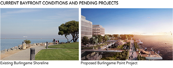
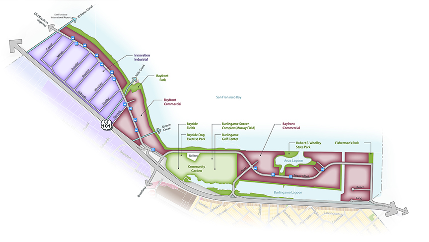
Burlingame’s Bayfront area covers approximately 2.5 linear miles of frontage along San Francisco Bay. The Bayfront is characterized by the open waters of the bay, important recreation and open space resources, and office buildings, hotels, and destination restaurants that benefit from their proximity to San Francisco International Airport. These commercial uses provide an important economic base for the City. Within the Bayfront Area, the Inner Bayshore district between Old Bayshore Highway and Highway 101 has long provided space for warehouses, industrial and logistic businesses, and office space that largely support uses at the airport.
Largely due to limited access across Highway 101, the Bayfront has developed somewhat independently from the rest of Burlingame, on properties that were once tidal lands and marshlands. The area is composed primarily of fill materials imported to development sites. The low-lying properties are exposed to flood risks and sea level rise hazards.
The regional Bay Trail runs along the Bayfront, providing a pedestrian and bicycle connection between recreation opportunities and services along the Bay. While the trail is substantially complete, gaps occur where the trail route crosses private lands (see Bayfront Diagram).
Bayfront Vision
The Bayfront will be a regional recreation and business destination. Enhanced parks, natural open spaces, and recreational amenities will offer places that residents and visitors can enjoy, with enhanced access for pedestrian, cyclists, and watercraft, including commercial ferry service. The area will be an environment where hotels and airport-related services continue to thrive, and where new commercial uses create a well-rounded district that serves a variety of needs. Industrial and office uses within the Inner Bayshore district will continue as preferred land uses, and compatible creative industries will be accommodated and encouraged. Long-term parking uses that serve operations at the airport will only be considered in conjunction with office and hospitality development, and only as a secondary or ancillary use. All development will be undertaken in a manner that protects people and property from flood hazards and sea level rise.
Goal: CC-5
Maintain and promote the Bayfront Area as a premier destination along San Francisco Bay for land- and water-based recreation, hospitality uses, creative industries, logistics support, water-based transit service, and local businesses that benefit from proximity to San Francisco International Airport.
Support and encourage commercial uses along the waterfront that enliven the area and serve as destinations for residents and visitors, including hotels, restaurants, and entertainment venues.
Continue to accommodate diverse industrial functions, and support emerging creative businesses through flexible zoning regulations.
Maintain the Bayfront’s industrial and airport support functions, and establish adaptable regulations that respond to the evolving nature of those industries.
Preserve and enhance Bayfront parks and open spaces, and identify strategies to increase usage of recreational amenities.
Coordinate with partner agencies to connect gaps in the Bay Trail, and require new waterfront development to improve and maintain trail segments along property lines.
Goal: CC-6
Establish a cohesive design character for the Bayfront Area that protects views to the waterfront, encourages walking and biking, accommodates water-based recreation and ferry service, and addresses sea level rise.
Ensure that new development preserves public views to the waterfront. Consider sightlines and viewsheds from Bayfront open spaces when planning future projects.
Consider the reuse of existing buildings as a sustainable option for accommodating creative commercial uses in the Innovation/Industrial District.
Encourage increased intensity via high-quality infill development on surface parking lots, and support the conversion of surface parking lots into active commercial and hospitality uses.
Establish design standards that facilitate attractive interfaces between use types, enhance the public realm, and activate commercial districts. Prioritize pedestrian improvements and waterfront access.
Improve pedestrian and bicycle access to the Bayfront across Highway 101 and along the Bay Trail, and identify opportunities for new bicycle and walking connections to key waterfront destinations.
Accommodate access to the Bay for water-based recreation and transit uses.
Require that new and existing development along the Bayfront make provisions for sea level rise and flood risks, which may involve payment of assessments to fund City or other efforts to build a unified defense system. Maintain minimum waterfront setback, with the setback area providing space in the future to accommodate sea level rise and flooding defenses. Design new buildings with habitable areas elevated to minimize potential damage from exceptional storm events.
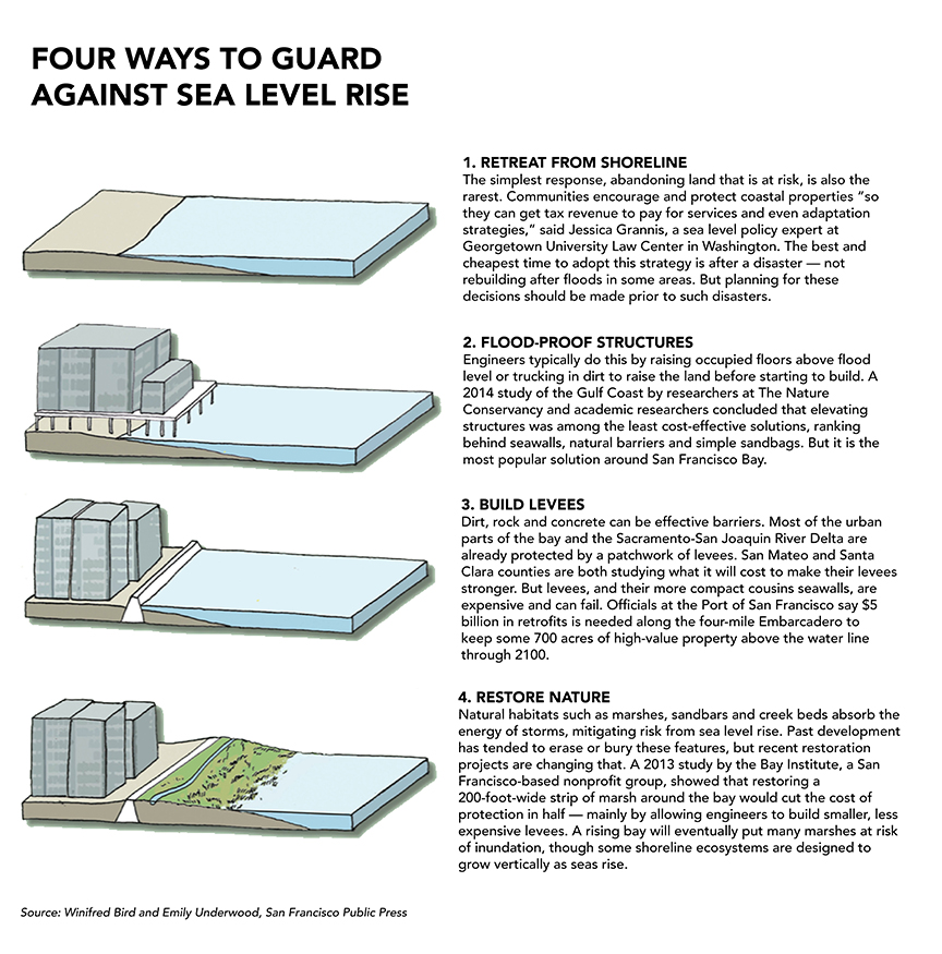
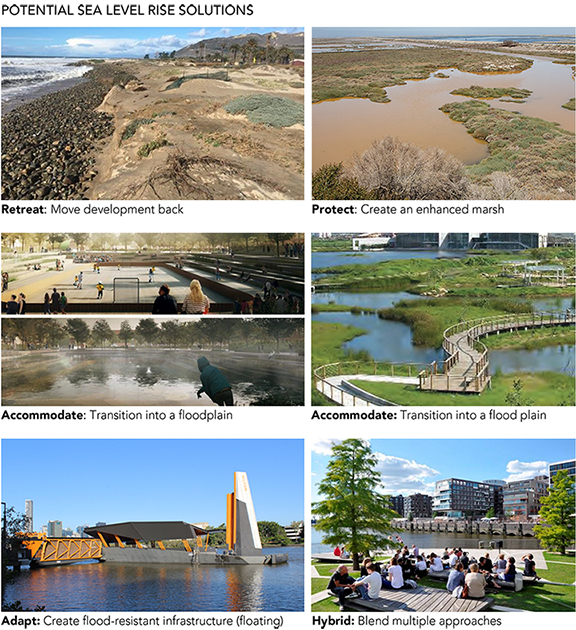
SEA LEVEL RISE
Sea Level Rise Approaches that communities typically consider: Protect, Accommodate, Retreat, Hybrid, and/or Adaptation. In Burlingame there may be limitations on some approaches, given current and future land uses along the shoreline, and the engineered nature of the land and shoreline.