Maps & Figures
Figure CC-1
Land Use Plan
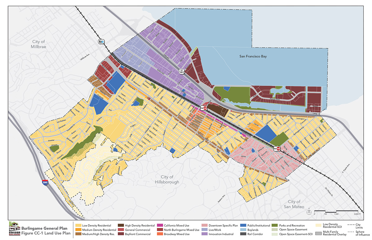
Figure CC-2
Designated Historical Structures and Places
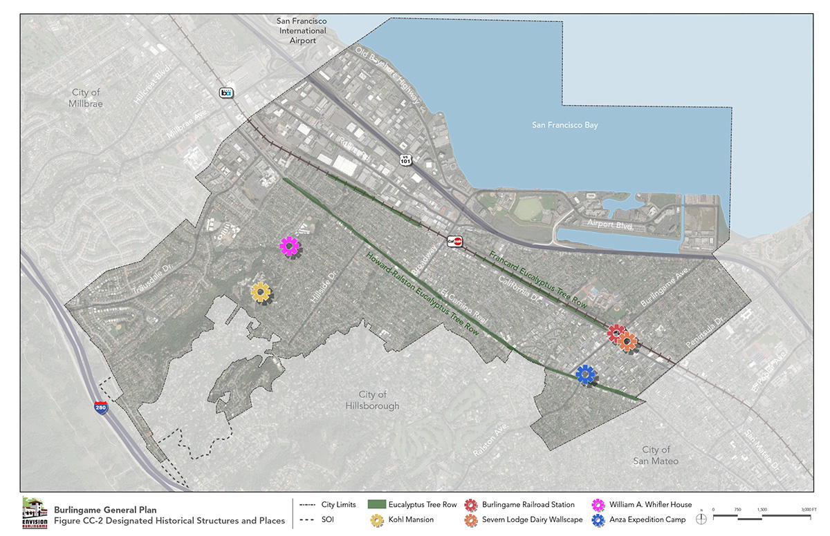
Figure CC-3
Neighborhoods Context Map
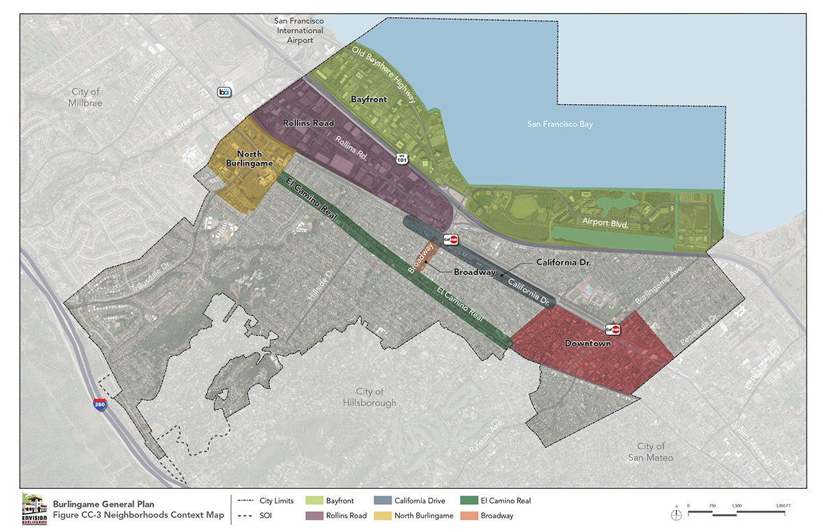
Figure CC-1
Land Use Plan
Figure CC-2
Designated Historical Structures and Places
Figure CC-3
Neighborhoods Context Map
Burlingame is a mature and built-out community with well-established residential neighborhoods. Many residential neighborhoods display architectural styles representing different eras of development, including the earliest periods of Burlingame’s history, and homeowners take great pride in home maintenance and neighborhood preservation.
Each of Burlingame’s neighborhoods reflects the building styles that were popular during the time of their construction. Older neighborhoods have an abundance of Craftsman and vernacular-style homes originally built in the 1910s and 1920s. These were typically made of wood shingles, wood siding, stucco, or a combination of these materials. By the early to mid-1920s, Tudor and Mediterranean-style homes gained popularity, creating an eclectic mix that generally is the hallmark of pre-1940s neighborhoods. Ranch-style and Eichler homes became popular between the 1940s and 1960s, and are particularly prevalent in post-WWII neighborhoods that developed following the subdivision of the Mills Estate on the north end of Burlingame.
The consistent neighborhood styles contribute to home values and neighborhood cohesion. However, evolving household compositions and increased disposable income among Burlingame residents has created tensions between homeowners’ desires to build larger homes and broader community interest in maintaining established neighborhood character. The following goal and policies aim to provide for new and substantially remodeled homes to be well integrated into existing neighborhood fabrics and landscapes. Also, long-established institutional uses such as churches, synagogues, convents, and private schools are integrated into several neighborhoods. Over time, the mission of these institutions may change, with the owners desiring to repurpose the properties. Such reuse will require careful consideration of their neighborhood context. Neighborhoods are shown in Figure CC-3.
Ensure high-quality, integrated, and appropriately scaled residential development within Burlingame’s neighborhoods.
Ensure that homes in the single family (R-1 zoned) neighborhoods retain the character of Burlingame as elucidated in the Burlingame Neighborhood Design Guidebook and by its regulations on Floor Area Ratio and massing, so as to ensure that new homes and remodels continue to meet Burlingame’s high design and aesthetic standards.
Emphasize attractive building and site design by paying careful attention to building scale, mass, placement, architecture, materials, landscaping, screening of equipment, loading areas, signage, and other design considerations.
Ensure that the scale and interrelationships of new and old residential development complement each other.
Ensure that the bulk and scale of multifamily residential developments are sensitive to homes and buildings in the surrounding area.
Regulate the design of streets, sidewalks, cluster home development, architecture, site design, grading, landscaping, and utilities in hillside areas to protect aesthetics, natural topography, and views of surrounding open space and distant landscapes.
Require development of a master plan or similar comprehensive planning tool for any proposed reuse/repurposing of the Sisters of Mercy campus (including Sisters Residences, Mercy Center, and Mercy High School) to accommodate its continuing mission, while ensuring that any new land uses and development scenarios integrate well with surrounding residential development and preserve the overall character of the campus as a community asset. Also require a master plan or similar tool for any large institution located within a residential neighborhood.
Focus areas are special examples of neighborhoods that will undergo significant change. These focus areas are shown below in Figure CC-3.
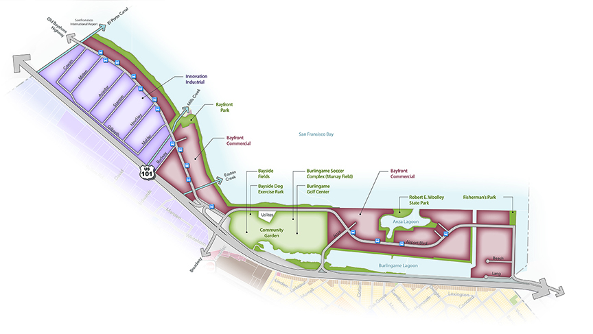
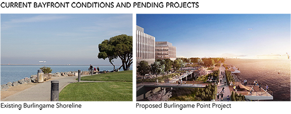
Burlingame’s Bayfront area covers approximately 2.5 linear miles of frontage along San Francisco Bay. The Bayfront is characterized by the open waters of the bay, important recreation and open space resources, and office buildings, hotels, and destination restaurants that benefit from their proximity to San Francisco International Airport. These commercial uses provide an important economic base for the City. Within the Bayfront Area, the Inner Bayshore district between Old Bayshore Highway and Highway 101 has long provided space for warehouses, industrial and logistic businesses, and office space that largely support uses at the airport.
Largely due to limited access across Highway 101, the Bayfront has developed somewhat independently from the rest of Burlingame, on properties that were once tidal lands and marshlands. The area is composed primarily of fill materials imported to development sites. The low-lying properties are exposed to flood risks and sea level rise hazards.
The regional Bay Trail runs along the Bayfront, providing a pedestrian and bicycle connection between recreation opportunities and services along the Bay. While the trail is substantially complete, gaps occur where the trail route crosses private lands (see Bayfront Diagram).
The Bayfront will be a regional recreation and business destination. Enhanced parks, natural open spaces, and recreational amenities will offer places that residents and visitors can enjoy, with enhanced access for pedestrian, cyclists, and watercraft, including commercial ferry service. The area will be an environment where hotels and airport-related services continue to thrive, and where new commercial uses create a well-rounded district that serves a variety of needs. Industrial and office uses within the Inner Bayshore district will continue as preferred land uses, and compatible creative industries will be accommodated and encouraged. Long-term parking uses that serve operations at the airport will only be considered in conjunction with office and hospitality development, and only as a secondary or ancillary use. All development will be undertaken in a manner that protects people and property from flood hazards and sea level rise.
Maintain and promote the Bayfront Area as a premier destination along San Francisco Bay for land- and water-based recreation, hospitality uses, creative industries, logistics support, water-based transit service, and local businesses that benefit from proximity to San Francisco International Airport.
Support and encourage commercial uses along the waterfront that enliven the area and serve as destinations for residents and visitors, including hotels, restaurants, and entertainment venues.
Continue to accommodate diverse industrial functions, and support emerging creative businesses through flexible zoning regulations.
Maintain the Bayfront’s industrial and airport support functions, and establish adaptable regulations that respond to the evolving nature of those industries.
Preserve and enhance Bayfront parks and open spaces, and identify strategies to increase usage of recreational amenities.
Coordinate with partner agencies to connect gaps in the Bay Trail, and require new waterfront development to improve and maintain trail segments along property lines.
Establish a cohesive design character for the Bayfront Area that protects views to the waterfront, encourages walking and biking, accommodates water-based recreation and ferry service, and addresses sea level rise.
Ensure that new development preserves public views to the waterfront. Consider sightlines and viewsheds from Bayfront open spaces when planning future projects.
Consider the reuse of existing buildings as a sustainable option for accommodating creative commercial uses in the Innovation/Industrial District.
Encourage increased intensity via high-quality infill development on surface parking lots, and support the conversion of surface parking lots into active commercial and hospitality uses.
Establish design standards that facilitate attractive interfaces between use types, enhance the public realm, and activate commercial districts. Prioritize pedestrian improvements and waterfront access.
Improve pedestrian and bicycle access to the Bayfront across Highway 101 and along the Bay Trail, and identify opportunities for new bicycle and walking connections to key waterfront destinations.
Accommodate access to the Bay for water-based recreation and transit uses.
Require that new and existing development along the Bayfront make provisions for sea level rise and flood risks, which may involve payment of assessments to fund City or other efforts to build a unified defense system. Maintain minimum waterfront setback, with the setback area providing space in the future to accommodate sea level rise and flooding defenses. Design new buildings with habitable areas elevated to minimize potential damage from exceptional storm events.
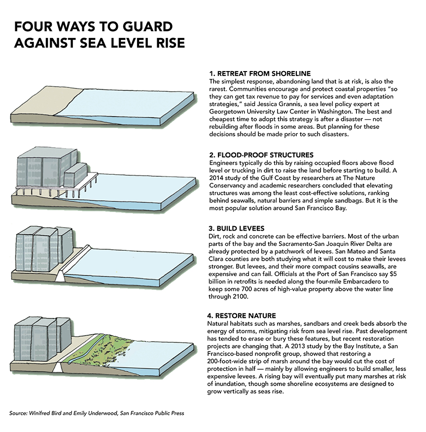
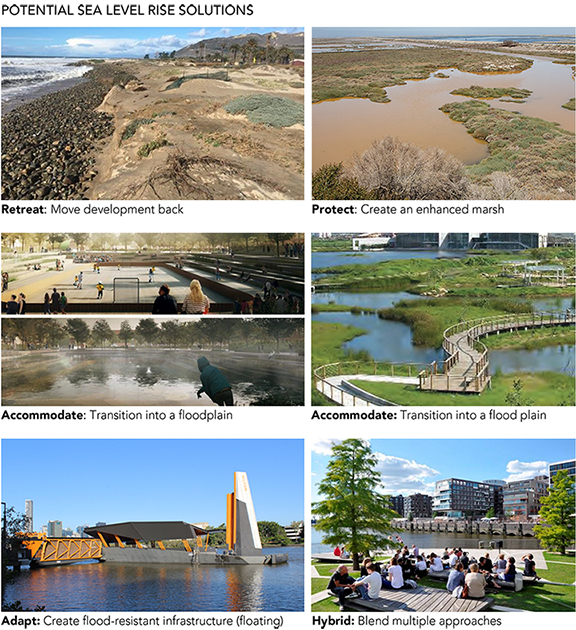
Sea Level Rise Approaches that communities typically consider: Protect, Accommodate, Retreat, Hybrid, and/or Adaptation. In Burlingame there may be limitations on some approaches, given current and future land uses along the shoreline, and the engineered nature of the land and shoreline.
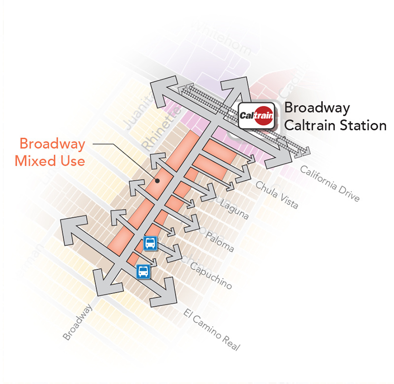
Broadway is one of two primary commercial destinations in the city and is known for its distinct, small-town main street character. Whereas Downtown supports a diverse mix of shops, restaurants, and professional offices with a regional emphasis—including a healthy distribution of national brand businesses—Broadway has a local, home-grown feel. The surrounding residential neighborhoods support these businesses with foot traffic. And although Broadway is a primary connection for vehicles traveling between Highway 101 and El Camino Real, the roadway’s narrow width and tree canopy work to maintain lower traffic speeds that support the pedestrian environment. Broadway’s charm is in its scale, focus on an active street front, and mixture of neighborhood and community-serving rather than regional-serving businesses (see Broadway Area Context Diagram).
Broadway will continue to be a commercial corridor, with a requirement for ground-floor uses and development approaches that encourage and support pedestrian activity. Public realm improvements and ongoing maintenance will create a distinctive look for the corridor. Increasing foot traffic, creating gathering places, and improving the façades will strengthen Broadway as a neighborhood district and preserve its distinct character and function. Residential development on upper floors along the Broadway frontage will bring additional people and vitality to the district. An emphasis will be placed on reuse and rehabilitation of character-defining structures. Infill development projects will respect and respond to the pedestrian scale and simple architectural styles. Building scales will include structures no higher than three stories (approximately 45 feet).
Ensure that Broadway maintains its character as a vibrant, pedestrian-friendly, mixed- use district that supports and encourages local businesses and local investment, and that serves as a gathering place for Burlingame residents and a quaint destination for visitors.
Encourage a diverse mix of commercial, office, and residential uses that support both daytime and evening activity, increase foot traffic, and attract visitors.
Ensure active and transparent ground-floor uses by restricting businesses fronting Broadway to retail, service, dining, and entertainment businesses.
Encourage second- and third-story office and residential uses along Broadway, and allow ground-floor office and residential (including lofts and live/work units) on side streets within the Broadway Mixed Use designation. Accommodate additional office space on ground floors of mixed use development on side streets.
Maintain the scale of development along Broadway to up to three stories, with more intensity at California Drive and El Camino Real. Ensure that residential and mixed use developments along side streets are designed and scaled to create a transition to lower-density residential neighborhoods.
Establish design standards for commercial and mixed-use development that reflect Broadway’s historical scale and character. Emphasize design elements that create an active ground-floor public realm and maintain the “rhythm” of storefront widths present in the district.
Enhance the gateways to the Broadway commercial district by protecting the sign at Broadway and California Drive, enhancing the use and design of the California Drive and El Camino Real intersections, and allowing more prominent development at those intersections as gateway signifiers.
Ensure pedestrian safety with intersection improvements and traffic-calming measures at key intersections along Broadway.
Maintain streetscape and sidewalk improvements along Broadway that encourage walking, improve accessibility, and create gathering spaces.
Continue to collaborate with the Broadway Business Improvement District (BID) to support and implement projects consistent with the goals of this General Plan. Facilitate two-way communication between business owners and the City.
Support and encourage efforts to better connect Broadway to surrounding neighborhoods and destinations via walking, bicycling, and public and private transit.
Improve parking management in the Broadway district by providing wayfinding signage and modern methods for collecting parking fares. Consider improvements to existing surface lots and/or incorporate public parking into a new structure.
Promote, and support a variety of events in the Broadway commercial district year-round, including events supported by the City, as well as events initiated by other organizations and the private sector.
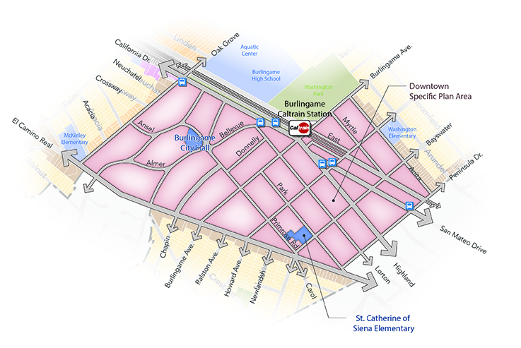
In 2010, the City Council adopted the Burlingame Downtown Specific Plan. This Specific Plan established direction for continuing the complementary mix of uses that allow Downtown to be a truly pedestrian-oriented place, anchored by the library and other civic uses, residential neighborhoods that offer a range of housing types, and restaurants and shops that locals frequent and visitors to Burlingame enjoy. The extensive streetscape improvements along Burlingame Avenue, completed in 2015, catalyzed private reinvestment along Downtown’s key artery and inspired interest and investment throughout the district. Given the proximity of Downtown to the Burlingame rail station, the Specific Plan creates opportunities for carefully located, more intense development projects that take advantage of easy transit access, and that respond to the desire of existing and prospective new residents to live in a charming, walkable environment that many compare to a European village (see Downtown Area Context Diagram).
As stated in the Burlingame Downtown Specific Plan, Downtown Burlingame will be an economically, socially, and culturally vibrant local and regional destination, with a diverse and balanced mix of activities, pedestrian-friendly streets, historical buildings, and inviting gathering places, including a public square. Burlingame Avenue will continue to be an active commercial venue, with restaurants, shops, and entertainment venues for locals and visitors. Over time, the mix of uses along other Downtown streets may shift in response to market conditions, with office uses, creative work spaces, and emerging business types occupying spaces traditionally devoted to commercial enterprises. New housing will be provided to meet all income levels and housing choices for people at all stages in their lives. Emphasis will continue to be placed on preserving historical structures, including the Post Office, and ensuring that new development projects blend with the aesthetic quality of their surroundings. And while walking will be the primary way to get around Downtown, the City will ensure that public parking facilities are well located, easy to find, demand priced, and attractive.
Ensure that Downtown maintains its character and function as a vibrant, pedestrian-scaled, mixed use district that supports and encourages a diversity of commercial businesses, treasured civic uses, activated office space, and housing for all income levels and people of all ages.
Encourage throughout Downtown a diverse mix of commercial, office, and residential uses that support both daytime and evening activity, take advantage of easy transit access, and distinguish Burlingame from other downtowns along the Peninsula.
Maintain Burlingame Avenue as an active commercial venue of regional importance and interest, with restaurants, shops, and entertainment venues for locals and visitors.
Maintain the scale of buildings throughout Downtown with pedestrians in mind, with new buildings emphasizing human-scale massing and architectural details. Require active storefronts and building fronts.
Ensure that the Burlingame Downtown Specific Plan maintains use regulations and standards that accommodate a diversity of housing types and affordability. Provide realistic incentives for affordable housing that is well integrated into development projects and throughout Downtown. Consider allowing additional density and housing configurations that fit within the height limits of the Downtown Specific Plan.
Ensure that the land use regulations in the Burlingame Downtown Specific Plan accommodate evolving markets for commercial and office space and do not constrain uses within particular sub-districts, provided that the diversity of uses throughout Downtown is retained. This includes flexibility of street frontage space along Howard Avenue, California Drive, Park Road, Lorton Avenue, and Highland Avenue.
Provide sidewalks, street furniture, street trees, and other streetscape and public realm amenities that preserve and enhance the comfortable pedestrian environment throughout Downtown.
Accommodate the continued presence of auto dealerships along California Drive, but also support the desire of property owners to reconfigure or redevelop properties along California Drive with other compatible uses consistent with the Burlingame Downtown Specific Plan.
Explore options for updating City Hall, with options to include rebuilding at the Primrose Road location or siting City Hall at another location convenient for residents and the business community.
Keep important civic uses in Downtown, and create new public gathering places, including a public square, through City efforts and public/private partnerships.
Establish programs that encourage the protection of historical buildings and features. Encourage adaptive reuse of historical buildings, including a historically compatible and sensitive redevelopment of the former U.S. Post Office in keeping with the Downtown Specific Plan.
Develop and implement a comprehensive public parking program for Downtown that utilizes surface lots and parking structures to accommodate demand associated with visitor traffic. The program should:
Establish parking regulations for private development projects in Downtown that recognize the pedestrian nature of the district, shared use of buildings, and proximity to transit. Allow for innovative parking approaches.
Design, implement, and maintain a modern wayfinding signage program throughout Downtown.
Promote, and support a variety of events in Downtown year-round, including events supported by the City, as well as events initiated by other organizations and the private sector.
Allow for development projects to incorporate variable massing approaches that provide for an overall average building height within an individual development project, rather than strict maximums.
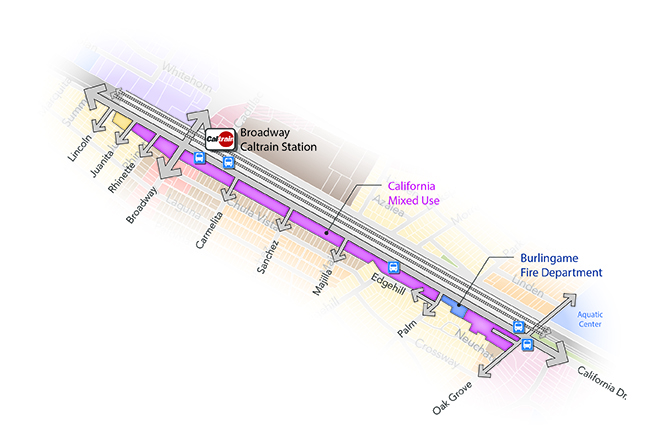
California Drive, from just north of Broadway to Oak Grove Avenue (the northern boundary of the Downtown district), has an eclectic character. The Caltrain right-of-way to the east forms a hard boundary, with an intermittent landscaped buffer between the tracks and California Drive. Low-scale commercial buildings—largely occupied by local businesses in buildings built to the front property line—are interspersed with residential uses either fronting California Drive or above and behind the commercial buildings. Despite the wide right-of-way of California Drive and traffic speeds of an arterial roadway, the street has characteristics of a pedestrian boulevard: a mix of complementary uses, buildings close to the street, and businesses focused on local needs. The right-of-way is wider than what is needed to accommodate anticipated traffic volumes through 2040, and pursuing a “road diet” (see the Mobility Element) for California Drive will create a slower, more pedestrian-friendly corridor that will influence land uses over the long term. The moderate-density residential neighborhoods behind the California Drive frontage define a building scale and sensitivity for uses along the street (see California Drive Area Context Diagram).
California Drive between Juanita Avenue and Oak Grove Avenue will remain a medium-density mixed use corridor that transitions seamlessly to the abutting residential districts to the west. An eclectic mix of uses reflective of long-established use patterns, a pedestrian scale, locally owned retail and service commercial businesses, and upper-story residential units will continue. Prototypical commercial uses are those that serve Burlingame residents and nearby communities, do not involve late-night hours, and do not have any operating characteristics that adversely impact residential uses. Stand-alone residential developments will accommodate local and regional demand for innovative and interesting housing types. California Drive will be reinvented as a fully multimodal corridor, with a separate bike lane and improved pedestrian connections along the west side of and across the road.
Preserve the California Drive district as an unconventional, eclectic place, where locally serving commercial businesses and varying types of residential development interact along a multimodal corridor, and the uses along California transition and interface quietly to neighborhoods behind the corridor.
Accommodate a diverse mix of low-scale, locally-serving commercial businesses and creative residential development along the corridor. In the zoning regulations, limit commercial uses to those that can clearly be considered compatible with established residential neighborhoods immediately adjacent.
Allow stand-alone residential development to remain at locations where historically established.
Encourage new development to be built to the California Drive frontage, and require step-down building setbacks and buffer treatments where commercial uses and higher-intensity residential development abut established residential neighborhoods to the immediate west.
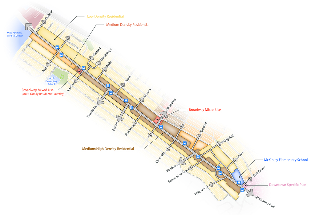
El Camino Real extends approximately 52 miles along the peninsula, connecting San Jose to San Francisco. Along most of its route, El Camino Real is known as State Route 82, a roadway maintained by Caltrans. In most communities, land uses developed along the route over time to respond to the road’s function as a commuter route, with motels and auto-oriented commercial businesses typifying the uses. Much of El Camino Real in Burlingame is an exception, however, with majestic eucalyptus trees lining the roadway and multifamily residential to each side. The apartments, townhomes, and condominiums along El Camino Real represent almost every era of architectural style from the 1920s forward, providing a diverse array of housing. Virtually absent along much of the stretch through Burlingame are the commercial uses that predominate in other communities (with the exceptions of the segment extending from Dufferin Avenue north to Millbrae, which is included within the North Burlingame planning area; commercial properties at the corner of Broadway and El Camino Real, which are included within the Broadway planning area; and commercial properties along the edge of Downtown from Chapin Avenue south, which are included in the Downtown planning area).
Nineteen cities, counties, and agencies are coordinating to reinvent El Camino Real through the “Grand Boulevard Initiative,” which aims to have the route “realize its full potential as a place for residents to work, live, shop, and play, creating links between communities that promote walking and transit and an improved and meaningful way of life.”[1] From Burlingame’s perspective, El Camino Real’s unique character through the city represents a window into the past and is a defining feature of Burlingame. From an urban character perspective, very little needs to change—and indeed, the eucalyptus grove itself is protected as an officially designated landmark so will endure into the future. The City has designated El Camino Real as a scenic roadway. From a street function perspective, there are opportunities for operational and safety enhancements, as discussed in the Mobility Element. See El Camino Real Area Context Diagram.
El Camino Real will continue to be an iconic roadway through Burlingame. Development along the densely tree-lined boulevard will consist of distinctive multifamily housing, with commercial development limited to properties that are within Downtown, at the intersection with Broadway, at a small node at Adeline Drive, and north of Dufferin Avenue. The City, in conjunction with Caltrans, will develop a plan to preserve the tree groves through management and a defined replanting plan for older trees. Traffic management and safety will be addressed as outlined in the Mobility Element, with clear direction to make El Camino Real pedestrian friendly through Burlingame.
Preserve the character of El Camino Real as a distinctive tree-lined corridor in Burlingame, clearly different than sections through other communities, with development consisting of multifamily housing of all types.
Maintain El Camino Real as a finely scaled, medium/high-density residential corridor, with supportive institutional uses.
Allow a limited amount of commercial and/or mixed-use development at key intersections along the corridor, and consistent with the Downtown Specific Plan. Apply a Medium-High Density Residential overlay to the Adeline Drive/El Camino Real commercial node, allowing either commercial, residential, or mixed commercial/residential development consistent with adjacent Medium-High Density Residential height and setback standards. Ensure the scale of development is compatible with established and adjacent uses along the corridor.
Establish design and landscape standards that maintain and strengthen the unique aesthetics of El Camino Real, and ensure compatibility with surrounding structures, including adjacent low-density residential. Policies protecting the Howard Ralston Tree Rows should extend along the entire length of the tree-lined corridor, including the edge of the Downtown Specific Plan area.
Enhance and celebrate the entry to Burlingame on El Camino Real with context-sensitive gateway design elements, including signage.
Balance the preservation and maintenance of the iconic tree groves along El Camino Real with public safety and consistent with the City’s Tree Preservation Ordinance.
Continue to partner with Caltrans, SamTrans, the Grand Boulevard Initiative, and other partners to improve multimodal safety and mobility along the corridor in a manner that reflects local priorities.
Provide for roadway improvements along the El Camino Real corridor as outlined in the Mobility Element.
The North Burlingame area represents a primary gateway as motorists travel south on El Camino Real. At this gateway, El Camino Real is a wide boulevard, with frontage roads providing access to the suburban-scale and character Burlingame Plaza commercial center and office buildings between the boulevard and railroad tracks. Significantly, this north end of the city has easy pedestrian access to the Millbrae multimodal transit station. Properties in Burlingame could support much more intense development due to the proximity to the multimodal transit station and to respond to housing needs for more diverse housing types. And while El Camino Real is under the jurisdiction of the California Department of Transportation (Caltrans), opportunities exist to make more efficient use of the street right-of-way. See North Burlingame Area Context Diagram.
North Burlingame will be a distinct, defining area of Burlingame, with streetscape enhancements, new housing, and complementary commercial uses at urban-level intensities. This transit-oriented development node will provide housing for all income levels, connect with surrounding commercial and institutional uses with improved pedestrian accommodations, and welcome visitors to Burlingame with distinguishing and historically sensitive gateway features.
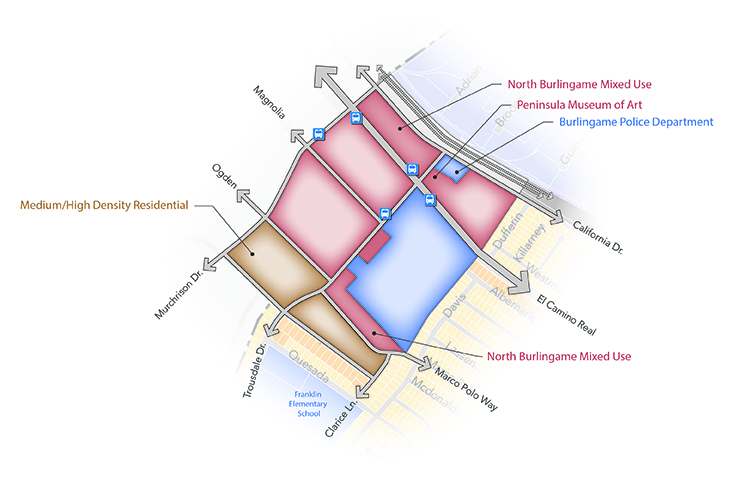
Establish a high-intensity mixed-use development node at the north end of El Camino Real to take advantage of the proximity to the Millbrae multimodal transit station and SamTrans commuter routes.
Promote a mix of residential and commercial uses, including a range of housing types and a mix of office, service, and retail uses that serve residents and complement the adjacent medical center.
Allow and encourage higher-density, transit-oriented development along El Camino Real and Trousdale Drive to provide housing, employment, and retail opportunities easily accessible from the Millbrae multimodal transit station and SamTrans commuter routes.
Encourage and support the development of new housing in North Burlingame. Ensure that new residential development provides a range of housing types available to different income levels and includes provisions for affordable housing.
Establish design and landscape standards and strategies to improve the streetscape, create a distinct development character, and create activity nodes while respecting the scale of nearby lower-density neighborhoods. Consider the following design strategies:
Develop and implement a defining gateway treatment on El Camino Real at the entrances to Burlingame. Use monuments, landscaping, and other streetscape elements as part of the design treatment.
Maintain and enhance frontage lanes along the east side of El Camino Real, with improvements such as wide sidewalks and generous landscaping to support pedestrian activity and serve as an amenity for adjacent buildings.
Ensure safe, comfortable crosswalks and intersections to support pedestrian and bicycle access to transit stops and across El Camino Real.
Encourage residents and employees in North Burlingame to shop, dine, and visit businesses along Broadway and in Downtown Burlingame.
The Rollins Road industrial corridor is a major employment base in Burlingame. Dating to the middle of the last century, the area largely has supported light manufacturing businesses, warehousing, auto repair shops, and wholesale sales activities. In the early 2000s, new uses setting up business in the district included commercial recreation businesses such as tennis clubs and indoor soccer facilities. Given the presence of the Millbrae multimodal transit station less than one-half mile from the north end of Rollins Road, the district presents opportunities for further evolution and particularly, to support housing development. However, with the diminishing availability of well-situated industrial properties in the Bay Area, balancing the need to preserve industrial land and businesses with the ability to accommodate emerging and desirable new uses will be a key challenge.
Rollins Road itself is a wide, four-lane thoroughfare with parking on both sides. Service and delivery trucks utilize the parking (and sometimes traffic) lanes during certain hours, and traffic on the street is relatively light. Currently, the corridor is not pedestrian friendly, as sidewalks are relatively narrow, buildings are set far back, and few pedestrian crossings are provided. Over time, the northern portion of Rollins Road in the Live/Work area should be enhanced to support pedestrian activity, balanced with continuing to accommodate truck traffic accessing the Innovation Industrial area to the south (see Rollins Area Context Diagram).
Rollins Road will primarily be an industrial district, particularly along the southern portion of the street within the Innovation/Industrial district. Traditional light industrial uses and auto service businesses will continue to represent key land uses since these provide vital services and jobs within the community, but allowing a cluster of creative and design industry activities to flourish will create synergies and a regional destination for wholesalers and consumers.
The northern portion of the corridor, within easy walking distance to the Millbrae multimodal transit station, presents an opportunity for establishment of a new neighborhood of medium- and high-density creative live/work units and support uses. The City envisions creation of a complete new neighborhood, where residents and creative businesses have ready access to transit, supportive commercial businesses, and public and private open space amenities. Such housing will include workforce housing, thus meeting the needs of all income levels in Burlingame. Streetscape improvements within the new neighborhood will emphasize a pedestrian focus, while still accommodating industrial-related traffic through to Millbrae Avenue.
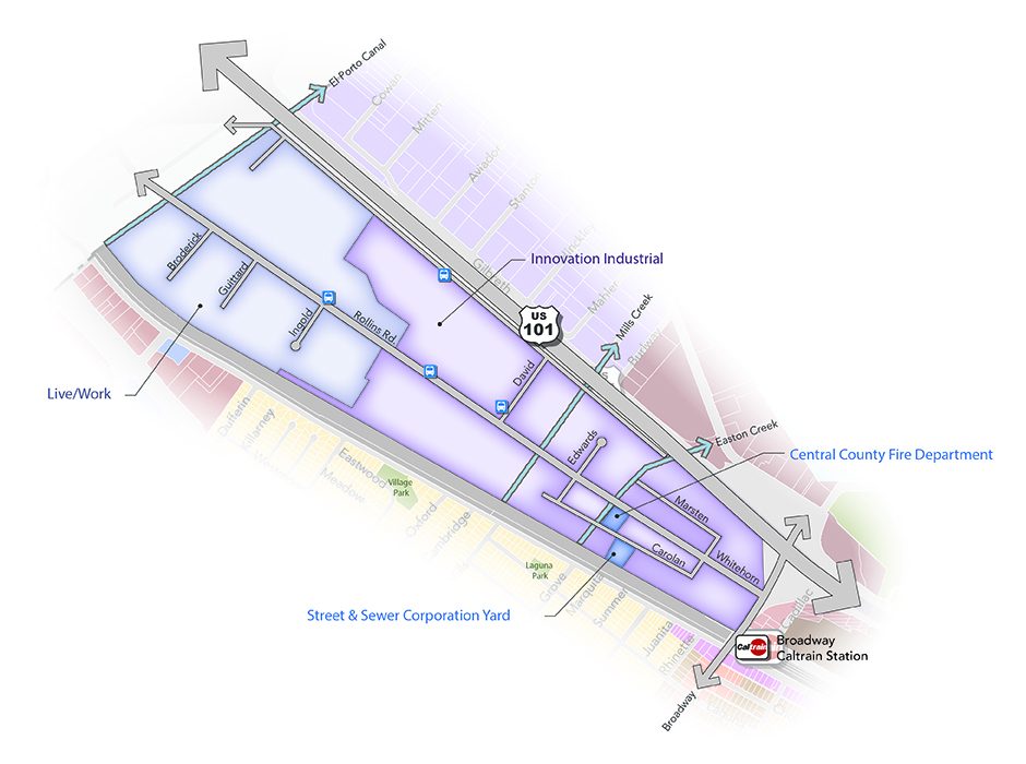
Recreate Rollins Road as two distinct but complementary districts, with the southern two-thirds of the corridor supporting industrial and creative business enterprises and the northern one-third of the corridor reimagined as a live/work complete residential neighborhood—with parks, tree-lined streets, and a pedestrian orientation—that connects to the Millbrae multimodal transit station.
Continue to support and accommodate the industrial and commercial uses throughout the Innovation/Industrial and Live/Work districts.
Support emerging businesses by establishing flexible zoning regulations that allow creative art and design-oriented and green-tech commercial and industrial uses.
Establish a creative Live/Work district at the north end of the Rollins Road corridor within approximately one-half mile of the Millbrae multimodal transit station; accommodate medium- and high-density residential uses either as stand-alone development or as integrated live/work environments.
Require new residential development in the Live/Work district to support alternative modes of transportation, including high-quality bicycle facilities and public transit incentives. Establish reduced parking requirements for residential buildings in this area, and study options for protected bike lanes along Rollins Road and improved connections from the Millbrae multimodal transit station.
Promote reuse of the existing building stock for creative commercial and industrial uses—and where feasible and desired, as residential and live/work places. Require aesthetic and façade improvements as part of redevelopment projects and property improvements.
Require development along the Highway 101 frontage to include attractive design elements, landscaping, and signage that create a positive aesthetic condition, as viewed from the highway corridor.
Establish an eclectic but cohesive design aesthetic for the Live/Work district, and require new development to utilize contemporary architectural treatments and materials that are compatible with the industrial nature of the area. Ground-floor workspaces should use transparent materials to activate sidewalks and support work functions.
Develop a vibrant public realm with attractive public spaces along the Rollins Road corridor by requiring new development to include publicly accessible plazas and pocket parks in appropriate locations.
Promote a pedestrian-friendly environment, particularly in the Live/Work district. Require new development to create active street frontages, with workspaces or commercial uses on the ground floor, attractive landscaping and street trees, and other streetscape enhancements as appropriate.
Study opportunities for signalized pedestrian crossings along Rollins Road, and identify pedestrian connectivity improvements between the Live/Work district and the Millbrae Multimodal BART station.
The City implements the General Plan goals and policies via programs. After closing this popup window, tap or click one of the program icons to go to a list of the programs that implement this and other related policies.
![]() Development Review (DR)
Development Review (DR)
![]() Master Plans (MP)
Master Plans (MP)
![]() Financing and Budgeting (FB)
Financing and Budgeting (FB)
![]() Studies and Reports (SR)
Studies and Reports (SR)
![]() Partnerships with the Private Sector (PA)
Partnerships with the Private Sector (PA)
![]() Public Information and Education (PI)
Public Information and Education (PI)
![]() Services and Operations (SO)
Services and Operations (SO)
![]() Agency Coordination (AC)
Agency Coordination (AC)